An online atlas of eastern Canadian Arctic trails, published two weeks ago, offers new perceptions about Inuit culture, according to the three authors responsible for the project. The new atlas, called Pan Inuit Trails, was compiled over the course of 15 years by Francis Taylor of Carleton University, Michael Bravo from the University of Cambridge, and Claudio Aporta at Dalhousie University.
 Taylor told one news source that the three researchers developed the project from the bottom up rather than from the top down—they paid lengthy visits to Inuit communities, seeking information from their elders as to the locations, uses, and meanings of trails across the land and sea. For the trails represent the stories of the people themselves, and their understandings of their environment.
“The journey is a story of what happened, who you met, who you saw, what kinds of things happened to you on that route. And every story is different,” Taylor said. “These geo-narratives are vitally important in understanding the richness of that journey.”
The importance of the work, he added, is that it should change perceptions by outsiders that the Inuit live in small, isolated communities. Instead, the atlas suggests the interconnections of “a thriving community which has moved and evolved and interacted over the course of time.”
Michael Bravo, from Cambridge, indicated that while the trails may not be distinguishable from the surrounding landscape by outsiders, to the Inuit, their contours and subtle features precisely mark their stories and narratives, a point similar to the one made by Tayor.
A different news source reported that Paingut Annie Peterloosie, an elder from Pond Inlet, provided the researchers with details about trails in her region that had been used for centuries. Bravo, commenting on the precision of her thinking, said that “she had the skill of moving like an Inuit seamstress, except it was across the Northwest Passage.”
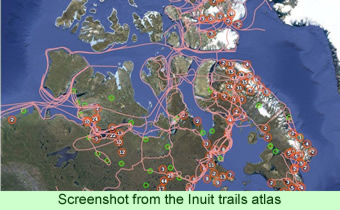
He added that the new atlas corrects the typical view of the Arctic as barren and mostly devoid of people with, instead, a sense of the richness of the land as the Inuit perceive it. “While many associate a single, squiggly line with the Northwest Passage, Inuit elders showed us, with great precision, how those trails intersect and join places where people have lived,” he said.
Claudio Aporta, the scholar from Dalhousie, first learned about the existence of trails in the Arctic in the year 2000 when he was traveling with some hunters in Igloolik. The hunters explained that the tracks he saw were trails that they had been using for many years—for as long as they could remember. “And they’re basically flattened-down snow, which melts,” he said, “but [each year] they create the same trails in the same [locations].”
The Inuit have carefully memorized their trails. Aporta said that they could remember specific features of the landscape, such as particular rocks, just by closing their eyes and focusing on the land they so often travel through. The researchers noted that while some of the trails are clearly hundreds of years old, the locations of others may be modified. For instance, changes in climate have affected the formation, and break-up, of sea ice, which may force deviations from traditional routes.
The compilers used many published and unpublished historical documents, as well as the memories of Inuit informants, to assist in the definitions of the trails portrayed in the atlas. One of the purposes of the project was to provide documentary source evidence of historic claims of Canadian sovereignty over the waters of the Canadian Arctic, especially the Northwest Passage.